
The Auberge L’Estive du Mercantour was welcoming and very practical for back packers.

For example, it was the only stopping place we found that offered a sink for washing clothes adjacent to a washing line. The manager was delightful, eager to help and knowledgable. Our dortoir had beds for 6 on 3 bunks and we shared the room with a French couple that we had met on the trail earlier that day. They were friendly and quiet. When we first arrived they were having an afternoon snooze in their bunks. The shower was more than excellent after two days without and after a clean up and a bit of rucksack sorting it was lovely to sit in the sun on the wide veranda and take in the sun and views, and a beer.
Dinner was good the main meal being plump round sausages cooked with lentils. We shared a dish with three Frenchmen, that I encountered later on. We had lunch time picnics from most of the previous Gites/Refuges, the ones from L’Estive were the most expensive at 8.50 Euros but also the most elaborate, a bulgar wheat salad with ham and cheese packed in a plastic box. It was a significant weight addition to our rucksacks. The breakfast was more than adequate and we were on our way by 8, as usual.
The route of the GR 52 has been changed in the last few years. An old TOPO guide I have, dated 2007, has the GR 52 avoiding Camp d’Argent and going direct from Pointe des Trois Communes to Sospel. In this guide it suggests that this takes nearly 9 hours of walking, and these are usually optimistic times; no allowance for stops. There is also nowhere to stop or stay on the route and only one unreliable water station. Quite an undertaking in other words. This new route is much more practical, but the stage to Sospel is still challenging about 23km long with a total descent of around 1700m, particularly in heat approaching 30C. On the strength of this analysis our dortoir French companions consulted the Auberge Manager and decided to walk some of the way then detour and bus for the remainder.
The new GR 52 track leaves the road about 100m down from L’Estive. It then more or less follows a contour across several hillsides; some tree-lined, others open sun-scorched meadow/scrub.  Eventually we climbed and reached a trackway that seemed to join some ruined military buildings with the redoubt we had seen the previous day. There were relics of WWII here in the shape of an American tank.

Stuart M3 light tank outside the ruins of barracks at Cabanes Vieilles
We encountered this track again a short while later on in the day and decided to follow it for a while because it was a good walking surface and avoided a few climbs and descents. We rejoined the Official GR 52 route at la Baisse de Ventabren (1862m) where the path leaves the track on the left. Up to this point, for some little while the valley views were on our right.

View from track in the direction of Moulinet
after Baisse de Ventabren the views were on our left and we crossed a scorched hillside
with lovely views in the direction of Breil sur Roya.
We had a better view over Breil when we stopped for our lunch in some sparse shade at Baisse de la Dea.

Breil sur Roya from la Baisse de la Dea (1750m)
After this lunch stop we walked across more open country in blazing hot weather and reached a minor airy peak with a cairn.

Mont Mangiabo (1821m)
From here the route was almost all downhill with some of it very steep. Initially, we were in open grassland. Later there was some shade from tree cover. It was a quite grueling descent and we were very pleased to see the valley start appearing.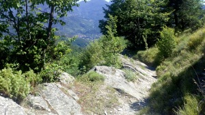
and then to see parts of the town of Sospel appear.
When we arrived in Sospel we were just about out of water and, after crossing the river, our first thought was to buy some water. But luckily we found a water fountain and drunk long from the cold water. (I forgot to take a picture but found this on a cycling website.)

We were rather disappointed to find that we had another climb to reach our overnight stop and were really relieved to get there, even though it was 7.15pm by that time and we had been walking, with stops, since 8am. The guide book indicates that this day’s walking is 6.5 hours. We were clearly walking slower, as we had found on previous days.
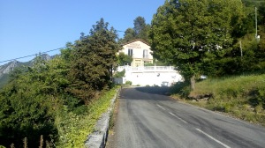
Auberge Provencale our overnight stop in Sospel
This was our most expensive overnight. We had a four bed unit with two single beds and a toilet shower on one floor and another two singles and shower toilet on an upper floor. We were in comparative luxury; no need to unpack our sleeping bags or our towels. I had only reserved beds but rather than face a walk back down into town to find something to eat we quickly changed that order to demi-pension. We ate that evening on the Auberge veranda overlooking Sospel  and were comfortable in t-shirts until around 10pm when we retired.
The exertions of that day, and the prospect of similar weather, distance and descent on the morrow, caused my three companions to decide to take the bus to Menton. Despite the guidebook indicating 7 hours of walking I decided that the final day, with the walk to the sea was an opportunity not to be missed.
Breakfast was a little later than normal, 7.30 and I set off walking at about 9am. The others left later after a look around Sospel town, then took a bus to Menton.
The GR trail follows the road going past the Auberge out of Sospel and leaves the road at a hairpin bend. It then climbs steeply initially along a rocky path then a track and then lots of climbing with several false summits until I reached a col. This point is marked on the map as Ruines a la Albarea (635m), Sospel is at 350m. From there it was down slightly and across a hillside and, then a climb into woods with loads of sweet chestnut leaves on the path. These gave way to fir cones as the path climbed higher, reaching the Col du Razet.

Col du Razet (1032m)
During this climb I had been passing and re-passing a group of three Frenchmen we had first met two days previously. During one stop they admitted to me that they had lost their path and just decided to follow me. At this col there was a water trough which they all but bathed in and then consulted their maps and decided to go to Castellar instead of Menton. So a while later we went our different ways.
From the Col du Razet there were increasingly dramatic views of the coast. The next stage of the walk took me across a sun-blasted rocky hillside with thistles, rough grasses, lavender, lizards and hordes of butterflies. The path goes through an old border post of the Franco-Italian border.

Remains of border post
There was another climb up to a new col.

Col de Colle-Basse (1107m)
At this point there was evidence of sheep folds and the path followed a rocky track down and across the hillside with more sea views.
After the track, it was good to enter some shade in woods onto a footpath for a climb mostly in trees. This was followed by a steep descent with zig zags to the Prairie de Morga.

Morga (810m) on the IGN map it is called Mourga
There were some houses in this vicinity and one was offering water and seats under a shady awning for tired walkers; a lovely touch, though I did not stop. Nearby there were ruins where I took this picture of the coast.
The path went down at this point to around 810m to join a track/road which climbed up the far side of a hill. This picture is taken looking back.
The GR left the track and started a long climb firstly across scrubby land and finally, near the top under some trees, to the Col du Berceau (1090m). I stopped here for lunch and was joined by another group of three Frenchmen with whom I compared notes about the walk. It was very hot, even in the shade, but the view of the coast was breathtaking.

View into Menton from the last high point of the day. The path down is just visible at the right of the picture
The descent from this col was loose and rocky and walking poles were a very useful aid.

Looking back to the Col du Berceau from the path down
Eventually, I reached a more even and less steep part and reached the Plan du Lion (710m).

Looking back from the Plan du Lion to Col du Berceau
This was a welcome interlude until I realised I needed to climb a bit again. Fortunately, it was not far and then there was a long (about 90 minutes) descent across arid hillsides with sharp, charred tree trunks and dry grasses. Under the hot sun it was good to reach a road and sit down in the shade for a short while in earshot of the motorway on the outskirts of Menton.
About twenty minutes later, I met up with my trek companions and was enjoying an orange presse in a bar on the promenade. Shortly after I was having a swim in the Med. I had started at about 9 and finished about 4 so 7 hours in total, which was just about what the guidebook said. It just shows that one person walks much faster than a group.
We finished our visit to the South of France by spending another day in Menton and then two days in Nice. All in all a wonderful trek and a lovely experience.

Menton Looking back from Italian border
